iPollution
Idea
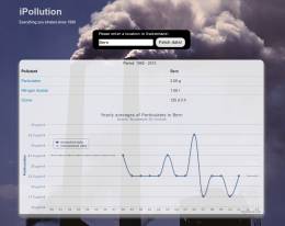
We extract the yearly mean values of the air pollution in Switzerland from the graphical maps on the BAFU website and present them to a user based on his location: A user should see the cumulative effect of being exposed to pollutants over years. We choose placative statistics, like the amount of particulate matter (PM10, Feinstaub) or the time one spends over the hourly limits of ozone.
The interpolated data for all Switzerland is not available in any other format. Although there is a lot of air pollution measurements downloadable, they are locally restricted to the measurement stations. The model behind the interpolation is rather complex and also not public.
As a consequence, the project takes an unusual approach: it actually extracts the data from maps, i.e. from pictures and re-maps the information to geocodes to offer personalized pollution data.
Data
databases currently used in the project
- Geocoded ZIP codes, File:
CSV (Excel) LV03
databases that could eventually be used in the project
Technology/Services
- http://flask.pocoo.org : the server backend is a simple python app that loads all pictures at startup and quickly calculates local pollution data
- http://heroku.com : free-for-small-projects webhosting for python web applications that supports virtual environments and continuous updates via git
- http://github.com : hosts source and data
Team
- Nicolai Kilian